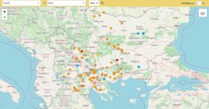
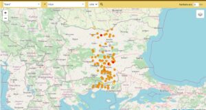
https://nisanyanmap.com/?y=*kara*&lv=&t=&chttps://nisanyanmap.com/?y=*kara*&lv=&t=&cry=&ua=5ry=&ua=5
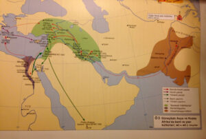
North is symbolized with Black colour in Turkish language. Well-known example is the Black Sea.
The black color in the north has various meanings, both dark and powerful.

Krani Krani village – Resen – MK
1910oh : Krani|Karahan
■ Albanian / Bulgarian settlement at the beginning of the 20th century . Albanian / Macedonian settlement
■ Coordinate: 40° 56′ 21” E, 21° 6′ 32” N
Karamani Карамани village – Bitola – MK
1910öh : Karaman [ Turkish ]
■ Bulgarian settlement at the beginning of the 20th century . Macedonian settlement now
■ Coordinate: 41° 3′ 52” E, 21° 23′ 38” N
Alintsi Алинци village – Prilep – MK
1910öh : Alintsi+Karataş [ Turkish “Ali” ]
■ Bulgarian settlement at the beginning of the 20th century . Macedonian settlement now
■ It was a mixed Turkish-Bulgarian village until the plague epidemic. As a result of the plague, most of the population perished, and the rest settled in the city of Prilep. metonyo
■ Coordinate: 41° 15′ 32” E, 21° 28′ 54” N
The dead settlement of Карабуњиште in Karabunysh – Veles – MK
■ Partially Bulgarian settlement at the beginning of the 20th century . Now unsaved/empty overlay
■ Coordinate: 41° 48′ 34” E, 21° 39′ 12” N
Mavropigí Μαυροπηγή village – Ptolemaída (Kailaríon) – Kozáni GR
B1913 : Bosovtsi|Karabunar
1910öh : Karapınar Καραμπουρνάρ [ Turkish ]
■ Bulgarian / Turkish settlement at the beginning of the 20th century .
■ Coordinate: 40° 27′ 1” E, 21° 43′ 48” N
Karabichane Карабичане village – Kumanovo – MK
■ Bulgarian settlement at the beginning of the 20th century . now Serbian settlement
■ Coordinate: 42° 13′ 44” E, 21° 44′ 29” N
Mavrodéndri Μαυροδένδρι village – Ptolemaída (Kailaríon) – Kozáni GR
1910öh : Elm Καραγάτς [ Turkish ]
■ Turkish settlement at the beginning of the 20th century .
■ Coordinate: 40° 23′ 11” E, 21° 46′ 8” N
Drépano Δρέπανον village – Kozáni – Kozani GR
1910öh : Karacalar Καρατζιλάρ [ Turkish ]
■ Turkish settlement at the beginning of the 20th century .
■ Coordinate: 40° 21′ 7” E, 21° 50′ 7” N
Gorno Karaslari Горно Караслари village – Veles – MK
■ Turkish settlement at the beginning of the 20th century . now Albanian settlement
■ Coordinate: 41° 41′ 45” E, 21° 50′ 11” N
Dolno Karaslari Долно Караслари village – Veles – MK
■ Bulgarian settlement at the beginning of the 20th century . Macedonian settlement now
■ Coordinate: 41° 41′ 21” E, 21° 50′ 16” N
Karatmanovo Каратманово village – Lozovo – MK
1910öh : Karaosmanlı [ Turkish ]
■ Turkish settlement at the beginning of the 20th century . Macedonian settlement now
■ Coordinate: 41° 45′ 46” E, 21° 52′ 4” N
Karacali Karahali neighborhood – Lozovo – MK
1910öh : Karacaali [ Turkish ]
■ Turkish settlement at the beginning of the 20th century . Macedonian settlement now
■ Coordinate: 41° 46′ 45” E, 21° 54′ 2” N
Bizovo location – Kavadartsi – MK
Former name: Bizov Çf.|Karasu
■ Bulgarian settlement at the beginning of the 20th century . Now unsaved/empty overlay
■ Coordinate: 41° 26′ 14” E, 21° 55′ 16” N
Lefkara Λεύκαρα village – Kozáni – Kozani GR
1910öh : Aksaklı/Aksakallı Ακ Σακλή [ Turkish ]
■ Turkish settlement at the beginning of the 20th century .
■ Coordinate: 40° 17′ 35” E, 21° 58′ 9” N
Kara Sinanli Кара Синанли dead settlement – Gradsko – MK
1910oh : Karasinanlı
■ Turkish settlement at the beginning of the 20th century . Now unsaved/empty overlay
■ Coordinate: 41° 39′ 10” E, 21° 59′ 40” N
Montenegro Karadak village – Kratovo – MK
■ Macedonian settlement
■ Coordinate: 42° 10′ 19” E, 22° 0′ 29” N
Almopía Αλμωπία administrative unit – Aridaía (Meglen) – Pélla GR
B1913 : Miglen/Meglen [ Bulgarian ]
T : Karacaova [ Turkish ]
■ Partially Pomak settlement at the beginning of the 20th century .
■ At the beginning of the 20th century, the population of the plain was mostly Pomaks, and Vlah and Yörük Turks as a minority. The Pomak and Turkish population were exchanged in 1924. Mostly Pontic Greeks were settled. SN
■ Coordinate: 40° 58′ 34” E, 22° 2′ 56” N
Karamanska Maala Караманска Маала village – Kratovo – MK
1910oh : Karaman Mah.
■ Coordinate: 42° 3′ 24” E, 22° 6′ 23” N
Kara Ocali Кара Оџали dead settlement – Negotino – MK
1910oh : Kara Khojaly
■ Turkish settlement at the beginning of the 20th century .
■ Coordinate: 41° 35′ 27” E, 22° 6′ 54” N
Mavrolákos dead settlement – Édessa (Vodina) – Pélla GR
1910öh : Karadere [ Turkish ]
■ There were two villages facing each other, Mavrolákos Edessis and Mavrolákos Giannitson (Bul. Karadere Vodenski and Karadere Pazarski). Karadere (Bul. Miglenitsa) river is the waterway of Karacaova (Miglen) region. SN
■ Coordinate: 40° 53′ 37” E, 22° 7′ 10” N
Miliás Μηλιάς village – Aridaía (Meglen) – Pélla GR
1910öh : Karalad/Kırladovo Καρλάτ
■ Pomak settlement at the beginning of the 20th century .
■ Coordinate: 40° 59′ 36” E, 22° 8′ 37” N
Kratovo Кратово municipalities – Kratovo – MK
Osm : Karatova
■ Turkish / Bulgarian settlement at the beginning of the 20th century . Macedonian settlement now
■ It is one of the rare towns with a homogeneous Bulgarian (Macedonian) population at the beginning of the 20th century. Only in the central town the Turks were in the majority. Now there is no Turkish population left. SN
■ Coordinate: 42° 4′ 42” E, 22° 10′ 50” N
Véroia province – Vérria (Karaferye) – Imathia GR
B1913 : Give
Osm : Karaferye
A17 : Verrone to
■ Turkish / Greek Orthodox settlement at the beginning of the 20th century .
■ Coordinate: 40° 31′ 46” E, 22° 12′ 2” N
Star Kara Forest Стар Караорман “old K.” village – Shtip – MK
1910oh : Karaorman A.Ş. + Approx. [ Turkish ]
■ Bulgarian settlement at the beginning of the 20th century . Macedonian settlement now
■ Coordinate: 41° 46′ 54” E, 22° 12′ 12” N
Nov Kara Forest Нов Караорман village – Karbintsi – MK
Former name: Karaormanite [ Bulgarian for “Kara foresters”]
■ Bulgarian settlement at the beginning of the 20th century . Macedonian settlement now
■ Coordinate: 41° 47′ 30” E, 22° 13′ 0” N
Kallípoli Καλλίπολις village – Giannitsá (Yenice Vardar) – Pélla GR
1910öh : Karahamza Καράμιζα
■ Coordinate: 40° 47′ 30” E, 22° 13′ 54” N
Mavrodéndri Μαυροδένδρι – Vérria (Karaferye) – Imathía GR
<1926 : Karaçalı Καρά Τσαλή [ Turkish “karaağaçlı?” ]
■ Turkish settlement at the beginning of the 20th century .
■ Coordinate: 40° 31′ 8” E, 22° 14′ 13” N
Karávi Καράβι dead settlement – Vérria (Karaferye) – Imathía GR
B1913 : Sadena/Sadina Σέδενα
■ Greek Orthodox settlement at the beginning of the 20th century .
■ Coordinate: 40° 31′ 59” E, 22° 18′ 1” N
Trkanye Тркање village – Koçani – MK
1910öh : Trakana|Carbine
■ Bulgarian settlement at the beginning of the 20th century . Macedonian settlement now
■ Coordinate: 41° 54′ 19” E, 22° 21′ 44” N
Karailyas dead settlement – Valandovo – MK
Former name: Karailyaslı
■ Turkish settlement at the beginning of the 20th century . Now unsaved/empty overlay
■ Coordinate: 41° 22′ 54” E, 22° 27′ 43” N
Karalobosi Каралобоси dead settlement – Radovish – MK
1910öh : Karaali Obası [ Turkish ]
■ Turkish settlement at the beginning of the 20th century . Now unsaved/empty overlay
■ Coordinate: 41° 40′ 33” E, 22° 29′ 14” N
Fawns Караџалар dead placement – Radovish – MK
1910öh : Karacalar [ Turkish ]
■ Turkish settlement at the beginning of the 20th century . Now unsaved/empty overlay
■ Coordinate: 41° 41′ 0” E, 22° 29′ 36” N
Plágia Πλάγια village – Gumenitsa – Kilkís GR
1910öh : Karasinan Καρασινάν [ Turkish ]
■ Turkish settlement at the beginning of the 20th century .
■ Coordinate: 41° 4′ 51” E, 22° 29′ 43” N
Políkastro Πολύκαστρο village – Kilkís – Kilkís GR
1910öh : Karasuli|Rugunovets Καρασούλι
1907s : Karasulu to
1997 : Paionía (prefecture) [ Greek for “fortress”]
■ Bulgarian / Turkish settlement at the beginning of the 20th century .
■ Coordinate: 40° 59′ 53” E, 22° 34′ 4” N
Karacovska Maala Караџовска Маала neighborhood – Makedonska Kamenitsa – MK
1910oh : Karaca Mah.
■ Coordinate: 42° 3′ 55” E, 22° 36′ 59” N
? dead settlement – Kilkís – Kilkís GR
1910oh : Arcan/Karacinovo
■ Its current name is unknown.
■ Bulgarian settlement at the beginning of the 20th century .
■ Coordinate: 41° 4′ 45” E, 22° 37′ 12” N
Kastanás Καστανάς village – Thessaloníki (Thessaloniki) – Thessaloníki_m GR
1910öh : Karaoğlu Καρά Ογλού [ Turkish ]
■ Turkish / Roman (Gypsy) settlement at the beginning of the 20th century .
■ Coordinate: 40° 49′ 16” E, 22° 39′ 28” N
Karaular dead settlement – Dojran – MK
1910öh : Karaoğullar
■ Turkish settlement at the beginning of the 20th century . Now unsaved/empty overlay
■ Coordinate: 41° 13′ 35” E, 22° 40′ 47” N
Néa Mesimvría Νέα Μεσημβρί village – Thessaloníki (Thessaloniki) – Thessaloníki_m GR
1953 : Karavia Καραβίας
B1913 : Bugarievo
1910oh : Bunarca
■ Bulgarian settlement at the beginning of the 20th century .
■ Coordinate: 40° 45′ 12” E, 22° 46′ 2” N
Agorá Αγορά dead settlement – Kilkís – Kilkís GR
1910öh : Karapazarlı Καρά Παζαρλή [ Turkish ]
■ Turkish settlement at the beginning of the 20th century .
■ Coordinate: 41° 15′ 55” E, 22° 46′ 35” N
Sykaminiá Συκαμινιά village – Kilkís – Kilkís GR
<1927 : Karali Καραλή [ Turkish ]
■ Coordinate: 41° 15′ 18” E, 22° 48′ 33” N
Mavronéri Μαυρονέρι “Karawater” village – Kilkís – Kilkís GR
1926 1926 : Karapınar Καρά Μπουνάρ [ Turkish ]
■ Turkish settlement at the beginning of the 20th century .
■ Coordinate: 40° 53′ 25” E, 22° 48′ 37” N
Karakostovtsi Каракостовци district – Delchevo – MK
■ Coordinate: 41° 51′ 10” E, 22° 50′ 8” N
Kallirrói Καλλιρρόη village – Kilkís – Kilkís GR
<1927 : Karacalı Καρατζαλή [ Turkish ]
■ Turkish settlement at the beginning of the 20th century .
■ Coordinate: 41° 14′ 11” E, 22° 50′ 38” N
Agia Triáda neighborhood – Thessaloníki (Thessaloniki) – Thessaloníki_m GR
1910oh : By. + stern. Karaburun [ Turkish ]
■ Greek Orthodox settlement at the beginning of the 20th century .
■ Coordinate: 40° 29′ 48” E, 22° 52′ 57” N
Koiládi Κοιλάδι village – Kilkís – Kilkís GR
<1927 : Karaahmatlı Καρά Αματλή [ Turkish ]
■ Turkish settlement at the beginning of the 20th century .
■ Coordinate: 41° 5′ 4” E, 22° 53′ 29” N
Mavroplagiá Μαυροπλαγιά village – Kilkís – Kilkís GR
<1927 : Karamahmutlu Καρά Μαμουτλή [ Turkish ]
■ Turkish settlement at the beginning of the 20th century .
■ Coordinate: 41° 11′ 10” E, 22° 53′ 57” N
Kampánis Καμπάνης village – Kilkís – Kilkís GR
<1955 : Válti Βάλτοι [ Greek ]
<1926 : Karathorn? Karacadir? Καρατζά [ Turkish ]
■ Bulgarian settlement at the beginning of the 20th century .
■ Coordinate: 40° 53′ 26” E, 22° 54′ 52” N
Cherno Pole Черно поле “ karaköy ” village – Rujintsi – Vidin BG
Former name: Karaova [ Turkish ]
■ Coordinate: 43° 36′ 48” E, 22° 55′ 21” N
Políhni Πολίχνη “town” village – Thessaloníki (Thessaloniki) – Thessaloníki_m GR
1910öh : Karaüseyin Καραϊσίν [ Turkish ]
■ Bulgarian settlement at the beginning of the 20th century .
■ Coordinate: 40° 39′ 58” E, 22° 56′ 34” N
Váthi Βάθη village – Kilkís – Kilkís GR
<1927 : Rayan Ραγιάν
1910öh : Karadağ|Rayanova [ Turkish / Bulgarian ]
■ Turkish / Bulgarian settlement at the beginning of the 20th century .
■ Coordinate: 41° 8′ 38” E, 22° 58′ 6” N
Kardiá Καρδιά village – Thessaloníki (Thessaloniki) – Thessaloníki_m GR
1910öh : Karaçuhalı Καρατζοχαλή [ Turkish ]
■ Turkish settlement at the beginning of the 20th century .
■ Coordinate: 40° 28′ 0” E, 22° 59′ 38” N
Kukurahtsevo Кукурахцево village – Petric – Blagoevgrad BG
1909hr : Kokarashtsevo
■ Coord: 41° 28′ 10” E, 22° 59′ 45” N
Mavrosúli Μαυροσούλι dead settlement – Sidirokástro (Demirhisar) – Serrés GR
<1927 : Karasuli Καρασούλι
■ Bulgarian settlement at the beginning of the 20th century .
■ Coordinate: 41° 12′ 9” E, 23° 2′ 56” N
Kryónero Κρυόνερο “cold water” dead settlement – Halkidikí – Halkidiki GR
1910öh : Karayusuflar/Karayusuflu Καρά Γιουσουφλάρ [ Turkish ]
■ Turkish settlement at the beginning of the 20th century .
■ Coordinate: 40° 22′ 13” E, 23° 4′ 14” N
Karterés Καρτερά village – Langadá (Langaza) – Thessaloníki GR
1910öh : Karacaköy Καρατζά Κιόι [ Turkish ]
■ Turkish settlement at the beginning of the 20th century .
■ Coordinate: 40° 54′ 33” E, 23° 4′ 58” N
Asproráhi Ασπροράχη “aktepe” dead settlement – Langadá (Langaza) – Thessaloníki GR
<1927 : Karaoba Καρά Ουμπάς [ Turkish ]
1924k : Karacaabad [ Turkish ]
■ Turkish settlement at the beginning of the 20th century .
■ While it was the central quarter of the Ottoman (Mavroráhi) group, it was abolished in 1940 after the Turkish population left. SN
■ Coordinate: 40° 51′ 20” E, 23° 6′ 0” N
Dolno Tserkovska neighborhood – Blagoevgrad – Blagoevgrad BG
1909hr : Karasu Çf .
■ Coordinate: 41° 56′ 44” E, 23° 6′ 2” N
Lofískos Λοφίσκος village – Langadá (Langaza) – Thessaloníki GR
1910öh : Karaömerli/Karamarlı Καρά Ομερλή [ Turkish ]
■ Turkish settlement at the beginning of the 20th century .
■ Coordinate: 40° 46′ 30” E, 23° 13′ 22” N
Néa Ténedos Νέα Τένεδος “new Bozcaada” village – Halkidiki – Halkidikí GR
1926 1926 : Karatepe Καρά Τεπέ [ Turkish ]
■ Turkish settlement at the beginning of the 20th century .
■ Coordinate: 40° 19′ 44” E, 23° 14′ 27” N
Pishurka Пишурка village – Medkovets – Montana BG
1910öh : Gray Kirri/Gray land?
■ Coordinate: 43° 39′ 22” E, 23° 15′ 3” N
Símandra Σήμαντρα village – Halkidikí – Halkidiki GR
1956 : Karkara Καρκάρα
1909hr : Mouthwash
■ Turkish settlement at the beginning of the 20th century .
■ Coord: 40° 20′ 54” E, 23° 18′ 27” N
Varikó Βαρικό village – Nigríta – Serrés GR
1910öh : Karacaköy Καρατζά Κιόι [ Turkish ]
■ Coordinate: 41° 1′ 22” E, 23° 23′ 36” N
Monokklisiá Μονοκκλησιά village – Serrés (Serez) – Serrés GR
1926 1926 : Karacaköy Καρατζά Κιόι [ Turkish ]
■ Coordinate: 41° 3′ 29” E, 23° 24′ 0” N
Métallo Μέταλλο dead settlement – Sidirokástro (Demirhisar) – Serrés GR
<1927 : Karatas Mah. Καρατάς
■ Turkish settlement at the beginning of the 20th century .
■ Coordinate: 41° 19′ 15” E, 23° 25′ 51” N
Ignatovo Игнатово village – Vilchedrim – Montana BG
1910öh : Karaleg |Ignatiyevo
■ Coordinate: 43° 47′ 2” E, 23° 29′ 9” N
Taşoluk Karakol location – Nigrita – Serres GR
■ The location at the provincial border of Serres/Thessaloniki is indicated by this name on the 1944 maps. SN
■ Coordinate: 40° 50′ 0” E, 23° 31′ 18” N
Agía Eléni Αγία Ελένη village – Serrés (Serez) – Serrés GR
<1927 : Kakaráska Κακαράσκα
■ Bulgarian settlement at the beginning of the 20th century .
■ Coordinate: 41° 0′ 14” E, 23° 33′ 29” N
Mavrólongos Μαυρόλογγος “ Kara forest ” dead settlement – Nigríta – Serrés GR
1910öh : Kara Forest Καρά Ορμάν [ Turkish ]
■ Karawood is the name of the large forest area along the Struma (Strymon) river. The settlement of the same name, between the old bed of the river and the new one, was dissolved in 1940. SN
■ Coordinate: 40° 58′ 3” E, 23° 36′ 7” N
Mesokómi Μεσοκώμη village – Serrés (Serez) – Serrés GR
<1927 : Kákara Κάκαρα
■ Coordinate: 41° 0′ 43” E, 23° 39′ 0” N
Katáfyto Κατάφυτο village – Káto Nevrokópi (Zirnovo) – Drama GR
1910öh : Karaköy Καρά Κιόι [ Turkish ]
■ Bulgarian settlement at the beginning of the 20th century .
■ Coordinate: 41° 21′ 6” E, 23° 41′ 22” N
Karapoltsi Караполци village – Elin Pelin – Sofia BG
1910h : Karapoltsi
■ Coordinate: 42° 37′ 13” E, 23° 42′ 1” N
Chernyovo Черньово village – Ihtiman – Sofia BG
1514t 1910öh : Karalar
■ Coordinate: 42° 24′ 57” E, 23° 45′ 42” N
Stambolovo Стамболово village – Ihtiman – Sofia BG
1910oh : Kara Apti
Former name: Bodrovo
■ Coordinate: 42° 24′ 10” E, 23° 48′ 45” N
Mavrólofos Μαυρόλοφος “ karatepe ” village – Néa Zíhni (Ziliahova) – Serrés GR
1910öh : Karatoprak Καρά Τοπράκ [ Turkish ]
■ Roman (Gypsy) settlement at the beginning of the 20th century .
■ Coordinate: 40° 54′ 54” E, 23° 52′ 13” N
Karaş Караш village – Roman – Vratsa BG
Former name: Karas
■ Coordinate: 43° 5′ 59” E, 23° 54′ 52” N
Kribul Крибул village – Satovish – Blagoevgrad BG
1909hr : Krabul/Karapul
■ Pomak settlement at the beginning of the 20th century .
■ Coordinate: 41° 34′ 22” E, 23° 56′ 45” N
Mavroléfki Μαυρολεύκη village – Dráma – Dráma GR
<1927 : poplar Καρά Καβάκ
■ Turkish settlement at the beginning of the 20th century .
■ Coordinate: 41° 3′ 21” E, 24° 5′ 58” N
Vinogradets Виноградец village – Septemvri – Pazarcik BG
1863h : Karamursal/Karamursel
■ Coordinate: 42° 17′ 30” E, 24° 7′ 32” N
Mavróvatos Μαυρόβατος village – Dráma – Dráma GR
<1927 : Karaçalı Καρά Τσαλή
■ Bulgarian / Roman (Gypsy) settlement at the beginning of the 20th century .
■ Coordinate: 41° 6′ 45” E, 24° 8′ 34” N
Karavangélis Καραβαγγέλης village – Eleftherúpoli (Praviste) – Kavála GR
1910öh : Debekli Δεβεκλή [ Turkish ]
■ Turkish settlement at the beginning of the 20th century .
■ Coordinate: 40° 51′ 8” E, 24° 9′ 50” N
Karabunar Карабунар village – Septemvri – Pazarcik BG
1863h : Karapinar
■ Coordinate: 42° 16′ 4” E, 24° 10′ 13” N
Borino Борино “ pine ” municipality – Borino – Smolyan BG
1863h : Karabulak
■ Turkish settlement
■ They are also known as Turks by the surrounding Pomaks. It is not enough for the Bulgarian Government to call the people in this region “Bulgarian Muslims”. It is the largest of the 8 settlements with representatives of the Middle Rhodope Nomads between the borders of Smolyan-Tatarpazarcık. metonyo
■ Coordinate: 41° 41′ 13” E, 24° 17′ 24” N
Elatiás Ελατιάς dead settlement – Dráma – Dráma GR
<1927 : Karadere Καρά Ντερέ [ Turkish ]
■ Pomak settlement at the beginning of the 20th century .
■ Abandoned mountain village on one of the most attractive hiking routes of the Rhodope Mountains. SN
■ Coordinate: 41° 29′ 20” E, 24° 17′ 45” N
Tsar Asen Цар Асен village – Pazarcik – Pazarcik BG
Former name: Karaplı
■ Coordinate: 42° 21′ 48” E, 24° 20′ 41” N
Terpsithéa Τερψιθέα village – Dráma – Dráma GR
<1927 : Karamanli? Καραμανλή
1910oh : Harmanli
■ Turkish settlement at the beginning of the 20th century .
■ Coordinate: 41° 9′ 34” E, 24° 22′ 13” N
Dobrovnitsa Добровница village – Pazarcik – Pazarcik BG
1910öh : Karailyasli/Karezli
■ Coordinate: 42° 12′ 55” E, 24° 22′ 31” N
Perívlepto Περίβλεπτον dead settlement – Dráma – Dráma GR
<1927 : Karagöz Καραγκιόζ Κιόι [ Turkish ]
■ Turkish settlement at the beginning of the 20th century .
■ Coordinate: 41° 17′ 5” E, 24° 24′ 23” N
Perigiáli neighborhood – Kavala – Kavála GR
1910öh : Kara Forest [ Turkish ]
■ Turkish / Greek Orthodox settlement at the beginning of the 20th century .
■ Coordinate: 40° 57′ 7” E, 24° 25′ 21” N
Thólos Θόλος village – Dráma – Dráma GR
<1927 : Karacaköy Καρατζάκιοϊ [ Turkish ]
■ Turkish settlement at the beginning of the 20th century .
■ Coordinate: 41° 17′ 48” E, 24° 31′ 13” N
Elafohóri Ελαφοχώρι “roe deer village” village – Néstos (Sarışaban) – Kavála GR
1910öh : Karacaova Καρατζόβα [ Turkish ]
■ Turkish settlement at the beginning of the 20th century .
■ The name Karaca, seen in three or four places in this region, probably means ‘Roman’. Translated into Greek as ‘deer’. SN
■ Coordinate: 41° 3′ 11” E, 24° 33′ 3” N
Yoakim Gruevo Йоаким Груев village – Stamboliyski – Plovdiv BG
1863h : Karatahir [ Turkish ]
■ Coordinate: 42° 7′ 17” E, 24° 33′ 45” N
Gortalovo Горталово village – Pleven – Pleven BG
1514t 1910öh : Karaguy [ Bulgarian ]
■ Coordinate: 43° 18′ 57” E, 24° 34′ 1” N
Dead settlement in Kalevish – Smolyan – Smolyan BG
Former name: Karabalkan
■ Coordinate: 41° 44′ 28” E, 24° 34′ 26” N
Brestovitsa Брестовица village with elm – Rodopi – Plovdiv BG
Former name: Karaağaç Yeniköy
■ Coordinate: 42° 4′ 45” E, 24° 35′ 30” N
Unknown on the map.
Dyakonovo village – Chernoochene – Kardzhali BG
Former name: Karabaşlar
Karali Карали village – Gabrovo – Gabrovo BG
Former name: Karali
Karandili village of Карандили – Elena – Veliko Tarnovo BG
Former name: Karandili
Karacovtsi dead settlement – Elena – Veliko Tarnovo BG
Sirnentsi Сърненци village – Veliko Tarnovo – Veliko Tarnovo BG
Former name: Karacovtsi
…………………………………………………….
Lyuben Любен “charming” village – Sıedineni to – Plovdiv BG
1863h : Karamustafalar
■ Coord: 42° 22′ 17” E, 24° 35′ 34” N
Brestovets Брестовец village with elm – Pleven – Pleven BG
Former name: Karaağaç [ Turkish ]
■ Coordinate: 43° 21′ 24” E, 24° 36′ 16” N
Stoletovo Столетово village – Karlovo – Plovdiv BG
Former name: Karasarlı
■ Coordinate: 42° 41′ 19” E, 24° 37′ 8” N
Voysil Войсил village – Maritsa – Plovdiv BG
1863h : Carnation
■ Coordinate: 42° 13′ 13” E, 24° 37′ 34” N
Pérni Πέρνη village – Néstos (Sarışaban) – Kavála GR
1910öh : Karacaköy [ Turkish ]
■ Turkish settlement at the beginning of the 20th century .
■ Coordinate: 41° 0′ 2” E, 24° 38′ 4” N
Zarkadiá Ζαρκαδιά village – Néstos (Sarışaban) – Kavála GR
1910öh : Karacalar Καρατζιλάρ [ Turkish ]
■ Turkish settlement at the beginning of the 20th century .
■ Coordinate: 41° 1′ 14” E, 24° 38′ 16” N
Karavelovo Каравелово village – Karlovo – Plovdiv BG
1863h : Köseler
■ Coordinate: 42° 37′ 35” E, 24° 39′ 20” N
Ágios Kosmás Άγιος Κοσμάς village – Néstos (Sarışaban) – Kavála GR
1910öh : Karamanlı Καραμανλή [ Turkish ]
■ Turkish settlement at the beginning of the 20th century .
■ The locations of Mayalık, Taviçal, Ahriyan and Büyük neighborhoods, which should be located between the west side of this village and the Nestos/Mesta river, could not be determined. SN
■ Coordinate: 41° 4′ 59” E, 24° 39′ 37” N
Chernalevo dead settlement – Smolyan – Smolyan BG
Former name: Karaburun
■ Coordinate: 41° 29′ 48” E, 24° 41′ 3” N
Lithohóri Λιθοχώρι dead settlement – Néstos (Sarışaban) – Kavála GR
1910öh : Karakadıl the Καρά Κιδαρλή [ Turkish ]
■ Turkish settlement at the beginning of the 20th century .
■ Coordinate: 41° 2′ 54” E, 24° 42′ 17” N
Karaboğaz neighborhood – Gulyantsi – Pleven BG
1910öh : Karaboğaz Çf . [ Turkish ]
■ Coordinate: 43° 41′ 2” E, 24° 42′ 30” N
Brestnik Брестник village – Rodopi – Plovdiv BG
1863h : Elm
■ Coord: 42° 3′ 20” E, 24° 45′ 55” N
Chernozem Bremen Черноземен “Karatoprak” village – Kaloyanovo – Plovdiv BG
1863h : Karatoprak [ Turkish ]
■ Coordinate: 42° 22′ 50” E, 24° 46′ 47” N
Eksohí Εξοχή “cottage” village – Ksánthi (Xanthi) – Ksánthi GR
1955 : Gizéla Γκιζέλα
1910öh : Karagözlü [ Turkish ]
■ Coordinate: 41° 1′ 51” E, 24° 51′ 39” N
Karacovo Караджово village – Sadovo – Plovdiv BG
1863h : Roe-Isa
■ Coordinate: 42° 5′ 54” E, 24° 54′ 8” N
Totleben Тотлебен village – Pordim – Pleven BG
1910öh : Bılgarski Karaağaç [ Bulgarian / Turkish ]
■ Eduard Totleben (1818-1884), one of the Tsarist generals, played a role in the 1877-78 Ottoman-Russian war. SN
■ Coordinate: 43° 26′ 15” E, 24° 54′ 29” N
Katrámio Κατράμιο village – Ksánthi (Xanthi) – Ksánthi GR
<1920 : Karaköy Καρά Κιόι [ Turkish ]
■ Coordinate: 41° 4′ 31” E, 24° 54′ 46” N
Kormisos village – Liki – Plovdiv BG
1863h : Karamus
■ 1880: 347 Turkish (possibly Pomak) metonio
■ Coordinate: 41° 45′ 57” E, 24° 56′ 0” N
Sirnegor Сърнегор “karacadağ” village – Brezovo – Plovdiv BG
1863h : Karaca Avhad
■ Coord: 42° 27′ 32” E, 24° 56′ 8” N
Alexandrovo Александрово village – Lovech – Lovech BG
<1882 : Karahasan
■ Coordinate: 43° 15′ 49” E, 24° 56′ 47” N
Bolyartsi Болярци village – Sadovo – Plovdiv BG
1863h : Karareis
■ Coordinate: 42° 3′ 59” E, 24° 57′ 10” N
Genisaía Γενισαία village – Ksánthi (Xanthi) – Ksánthi GR
1950 1950 : Genisea
Osm : Yenice-i Karasu Γενιτζέ [ Turkish ]
1997 : Vistónida (prefecture)
■ Turkish settlement
■ The town, which was the administrative center of the region and the main Turkish settlement during the Ottoman period, lost its importance when the sanjak center was moved to Xanthi (Xsanthi) in the mid-19th century. SN
■ Coordinate: 41° 3′ 42” E, 24° 57′ 37” N
Pezúla Πεζούλα village – Ksánthi (Xanthi) – Ksánthi GR
<1920 : Karapazar Καραπαζαρλάρ [ Turkish ]
■ Coordinate: 41° 0′ 22” E, 24° 57′ 40” N
Áskyra Άσκυρα village – Ksánthi (Xanthi) – Ksánthi GR
1910oh : Virane Han Mah.
<1920 : Karaoğlan Καρά Ουλάν (mountain) [ Turkish ]
■ Coordinate: 41° 11′ 43” E, 25° 0′ 42” N
Símantra Σήμαντρα village – Ksánthi (Xanthi) – Ksánthi GR
1909hr : Karacanlı/Karacanlar [ Turkish ]
■ Coordinate: 41° 8′ 16” E, 25° 1′ 32” N
Bolyarino Болярино village – Rakovsky – Plovdiv BG
Former name: Beyköy
1863h : Karabey
■ Coordinate: 42° 14′ 16” E, 25° 2′ 47” N
Karamichevtsi Карамичевци village – Sevlievo – Gabrovo BG
1514t : Karamichevska
■ Coordinate: 42° 53′ 50” E, 25° 4′ 13” N
Opalchenets Опълченец village – Bratya Daskalovi – Stara Zagora BG
1863h : Unruly Lands
■ Coordinate: 42° 12′ 35” E, 25° 7′ 21” N
Iskra Искра village – Pırvomay – Plovdiv BG
1906-1950 : Popovo
1863h : Fawns
■ Coordinate: 41° 55′ 58” E, 25° 7′ 52” N
Levski Левски municipality – Levski – Pleven BG
1514t : Karaağaç [ Turkish ]
■ Coordinate: 43° 21′ 39” E, 25° 8′ 25” N
Vrlino Върлино village – Nedelino – Smolyan BG
Former name: Karayokuş
■ Coordinate: 41° 28′ 16” E, 25° 9′ 40” N
Chernigovo Чернигово village – Ardino – Kardzhali BG
Former name: Cherni Vrih
Former name: Karamusallar
■ Coordinate: 41° 39′ 33” E, 25° 10′ 12” N
Bryagovo Брягово village – Pırvomay – Plovdiv BG
1863h : Karaalan
■ Coordinate: 41° 59′ 7” E, 25° 10′ 24” N
Voynovo Войново village – Chernoochene – Kardzhali BG
1909hr : Kobaks
Former name: Kara Boys
■ Coordinate: 41° 45′ 1” E, 25° 10′ 39” N
Glykonéri Γλυκονέρι “freshwater” village – Komotiní ( Comotyne ) – Rodópi GR
<1920 : Karapınar Καρά Μπουνάρ [ Turkish ]
■ Coordinate: 41° 0′ 54” E, 25° 11′ 20” N
Tríkorfo Τρίκορφο “three peaks” neighborhood – Komotiní ( Comotyne ) – Rodópi GR
<1920 : Mountain Karamusa Νταγ Καρά Μουσά [ English ]
■ Coordinate: 41° 11′ 33” E, 25° 11′ 26” N
Mosaikó Μωσαϊκό village – Komotiní ( Comotyne ) – Rodópi GR
<1920 : Karamusa Καρά Μουσά [ Turkish ]
■ Coordinate: 41° 5′ 35” E, 25° 11′ 43” N
Zdravchets Здравчец village – Kirkovo – Kardzhali BG
Former name: Karabaşlar
■ Coordinate: 41° 23′ 54” E, 25° 12′ 55” N
Cherna Gora Черна гора “montenegro” village – Bratya Daskalovi – Stara Zagora BG
1863h : Kara Forest
■ Coordinate: 42° 13′ 8” E, 25° 13′ 27” N
Borovskoe Боровско “çamlı” village – Çernooç until – Kardzhali BG
1909hr : Karamanlar
■ Coordinate: 41° 44′ 2” E, 25° 13′ 56” N
Zagorski Загорски village – Kirkovo – Kardzhali BG
1910oh : Karacalar Mah.
■ Coordinate: 41° 24′ 21” E, 25° 14′ 4” N
Viden Виден village – Pavel Banya – Stara Zagora BG
1863h : Karayiğitl of
■ Coordinate: 42° 36′ 7” E, 25° 14′ 9” N
Dedets Дедец village – Kirkovo – Kardzhali BG
Former name: Dedekaracalar/Dedeler
■ Coordinate: 41° 23′ 36” E, 25° 14′ 26” N
Cherna Niva Черна нива village – Chernoochene – Kardzhali BG
Former name: Karatarla
■ Coord: 41° 46′ 45” E, 25° 15′ 54” N
Brandy Каняк village – Çernooç until – Kardzhali BG
Former name: Karaköy İbikler
■ Coordinate: 41° 45′ 23” E, 25° 16′ 54” N
Karacalovo Караджалово village – Pırvomay – Plovdiv BG
1863h : KARACAHALİL
■ Coordinate: 42° 5′ 53” E, 25° 18′ 52” N
Bryastovo Брястово village with elm – Mineralni Bani – Haskovo BG
1863h : Elm
■ Coordinate: 41° 55′ 28” E, 25° 19′ 9” N
Karamantsi Караманци village – Mineralni Bani – Haskovo BG
1863h : Karamanlar
■ Coordinate: 41° 50′ 11” E, 25° 19′ 43” N
Sirnevets Сърневец village – Bratya Daskalovi – Stara Zagora BG
1863h : Karacaviran
■ Coordinate: 42° 24′ 25” E, 25° 20′ 20” N
Karaisen Караисен village – Pavlikeni – Veliko Tarnovo BG
Former name: Kara Isen
■ Coordinate: 43° 22′ 41” E, 25° 20′ 40” N
Çernooç until Черноочене “bream” municipalities – Çernooç until – Kardzhali BG
Former name: Karagözler|Yenipazar [ Turkish ]
■ It is a town that developed after the border drawn in 1885 remained on the Ottoman side. It does not appear on old maps. SN
■ Coordinate: 41° 45′ 43” E, 25° 20′ 54” N
Stoyan-Zaimovo Стоян-Заимов village – Chirpan – Stara Zagora BG
Former name: Bednyakovo
1863h : Karacaviran
■ Coordinate: 42° 20′ 41” E, 25° 21′ 6” N
Jeleznik Железник village – Chernoochene – Kardzhali BG
1909hr : Karademir
■ Coordinate: 41° 44′ 30” E, 25° 21′ 8” N
Cerna Skala Черна скала village – Kardzhali – Kardzhali BG
1863h : Karakaya
■ Coordinate: 41° 42′ 0” E, 25° 21′ 32” N
Skobelevo Скобелево village – Dimitrovgrad – Haskovo BG
1863h : Karahisarlı
■ Coordinate: 42° 5′ 50” E, 25° 21′ 45” N
Mavrommáti Μαυρομμάτι village – Komotiní ( Comotyne ) – Rodópi GR
<1920 : Karagözlü Καρά Γκιοζλού [ Turkish ]
■ Coordinate: 41° 0′ 15” E, 25° 23′ 1” N
Lozengradtsi Лозенградци village – Kirkovo – Kardzhali BG
Former name: Karakaş
■ Coordinate: 41° 17′ 49” E, 25° 23′ 55” N
Karaivantsa Караиванца village – Dryanovo – Gabrovo BG
Former name: Karaivantsa
■ Coordinate: 42° 59′ 3” E, 25° 24′ 16” N
Gita Гита village – Chirpan – Stara Zagora BG
Former name: Zapadno Shivachevo
1863h : Characters
■ Coordinate: 42° 12′ 8” E, 25° 27′ 20” N
Maslarevo Масларево village – Polski Trambesh – Veliko Tarnovo BG
Former name: Oiler
1514t : Karaaycı?
■ Coordinate: 43° 24′ 48” E, 25° 27′ 38” N
Gorna Krepost Горна крепос village – Kardzhali – Kardzhali BG
Former name: Yk. lands
■ Coordinate: 41° 43′ 32” E, 25° 27′ 49” N
Grivyak Гривяк village – Kirkovo – Kardzhali BG
Former name: Karaahmetler
■ Coordinate: 41° 23′ 23” E, 25° 28′ 18” N
Karamanovo Караманово village – Tsenovo – Ruse BG
1514t : Karaman [ Turkish ]
■ Coordinate: 43° 32′ 50” E, 25° 31′ 36” N
Chernyovtsi Черньовци village – Kardzhali – Kardzhali BG
Former name: Karamusas
■ Coordinate: 41° 43′ 34” E, 25° 31′ 46” N
Malka Vereya Малка Верея village – Stara Zagora – Stara Zagora BG
1863h : Karaveliler
■ Coordinate: 42° 24′ 15” E, 25° 32′ 24” N
Tulip Лале village – Momchilgrad – Kardzhali BG
1863h <1934 : Karakoy
■ Coordinate: 41° 31′ 15” E, 25° 32′ 43” N
Áratos village – Komotiní ( Comotyne ) – Rodópi GR
1909hr : Karacaoğlan [ Turkish ]
■ Coordinate: 41° 4′ 55” E, 25° 32′ 58” N
Kaloyants the Калоянци village – Kardzhali – Kardzhali BG
Former name: Karabahisli
■ Coordinate: 41° 40′ 2” E, 25° 33′ 1” N
Krovýli Κρωβύλη village – Komotiní ( Comotini ) – Rodópi GR
<1920 : Kara Kardzhali Καρά Κουρτζαλή [ Turkish ]
■ Coordinate: 40° 57′ 22” E, 25° 33′ 33” N
Dióni Διώνη village – Komotiní ( Comotyne ) – Rodópi GR
<1920 : Elm Καρά Αγάτς [ Turkish ]
■ Coordinate: 40° 58′ 46” E, 25° 33′ 47” N
Carnation Карамфил village – Momchilgrad – Kardzhali BG
1910öh : Kulfalı [ Turkish ]
■ Coordinate: 41° 29′ 15” E, 25° 34′ 26” N
Bryast Бряст “elm” village – Dimitrovgrad – Haskovo BG
1863h : Elm
■ Coordinate: 42° 6′ 29” E, 25° 35′ 0” N
Dimitrovgrad Димитровград municipality – Dimitrovgrad – Haskovo BG
1863h : Karacaoluk [ Turkish ]
■ Coordinate: 42° 3′ 25” E, 25° 35′ 4” N
Elenino Еленино village – Stara Zagora – Stara Zagora BG
1863h : Karaite/Karagitian
■ Coordinate: 42° 22′ 9” E, 25° 36′ 3” N
Konevo Конево village – Kardzhali – Kardzhali BG
Former name: Karaahatlar/Karaatlar
■ Coordinate: 41° 40′ 27” E, 25° 36′ 22” N
Limets Лимец village – Krumovgrad – Kardzhali BG
Former name: Karasabanlar
■ Coordinate: 41° 22′ 33” E, 25° 37′ 29” N
Petko Karavelovo Петко Караве village – Polski Trambeş – Veliko Tarnovo BG
1951- : Sashevo
1942-1951 : Petko Karavelovo
Former name: Rooms
1878-1942 : Odaite
■ Coordinate: 43° 18′ 9” E, 25° 38′ 45” N
Chernogorovo Черногорово “montenegro” village – Dimitrovgrad – Haskovo BG
1863h : Kara Forest [ Turkish ]
■ Coordinate: 42° 1′ 52” E, 25° 39′ 3” N
Filip Totevo dead settlement – Veliko Tarnovo – Veliko Tarnovo BG
Former name: Karahasanlar
■ Coordinate: 42° 53′ 57” E, 25° 40′ 3” N
Polkovnik Jelyazovo Полковник Же “Colonel J” village – Krumovgrad – Kardzhali BG
Former name: Karademirler
■ Coordinate: 41° 28′ 1” E, 25° 40′ 15” N
Karantsi Каранци village – Polski Trambesh – Veliko Tarnovo BG
1514t : Karamca
■ Coordinate: 43° 23′ 17” E, 25° 40′ 37” N
Vodentsi Воденци village – Stambolovo – Haskovo BG
1909hr : Karamusas
■ Coordinate: 41° 41′ 8” E, 25° 41′ 2” N
Moryantsi Морянци village – Krumovgrad – Kardzhali BG
Former name: Karapinar
■ Coordinate: 41° 35′ 23” E, 25° 41′ 51” N
Pelin Пелин village – Krumovgrad – Kardzhali BG
Former name: Karabeyli
■ Coordinate: 41° 27′ 58” E, 25° 44′ 2” N
Chernooki Чернооки “karagöz” village – Krumovgrad – Kardzhali BG
Former name: Karagöz [ Turkish ]
■ Coordinate: 41° 26′ 39” E, 25° 46′ 15” N
Ekzarh Yosif Екзарх Йосиф village – Borovo – Ruse BG
Former name: Karakocalı [ Turkish ]
■ Coordinate: 43° 36′ 58” E, 25° 47′ 0” N
Velikovo Великово village – Galabovo – Stara Zagora BG
1863h : Karamanli
■ Coordinate: 42° 11′ 15” E, 25° 47′ 52” N
Karaivantsi Караиванци village – Elena – Veliko Tarnovo BG
1514t : Karaivanica
■ Coord: 42° 48′ 21” E, 25° 48′ 28” N
Sirnevo Сърнево village with “karaca” – Radnevo – Stara Zagora BG
1863h : Karacalı/Karacahalilli
■ Coordinate: 42° 21′ 24” E, 25° 50′ 2” N
Mavrópetra Μαυρόπετρα dead settlement – Aleksandrupóli (Alexandroupolis) – Évros GR
1910öh : Karakaya Καρακαγιά [ Turkish ]
■ Coordinate: 40° 59′ 27” E, 25° 50′ 38” N
Gılıbovo Гълъбово municipalities – Galabovo – Stara Zagora BG
Former name: Kladenchevo
1863h : Karapinar
■ Coordinate: 42° 8′ 36” E, 25° 51′ 52” N
Podslon Подслон village – Stara Zagora – Stara Zagora BG
1902-1950 : Tsarevo
1863h : Karabunar
■ Coordinate: 42° 28′ 31” E, 25° 52′ 6” N
Lozen Лозен village – Strajitsa – Veliko Tarnovo BG
Former name: Karahasan
■ Coordinate: 43° 19′ 31” E, 25° 52′ 15” N
Harádra Χαράδρα neighborhood – Komotiní ( Comotyne ) – Rodópi GR
<1920 : Karadere [ Turkish ]
■ Coordinate: 41° 11′ 12” E, 25° 53′ 20” N
Znamenosets Знаменосец village – Radnevo – Stara Zagora BG
1863h : Karaburun
■ Coordinate: 42° 16′ 54” E, 25° 53′ 56” N
Karanovo Караново village – Nova Zagora – Sliven BG
1863h : Kisbetli
■ Coordinate: 42° 30′ 48” E, 25° 54′ 46” N
Karlovsko Карловско village – Ivaylovgrad – Haskovo BG
1934 : Karlovo
1909hr : Karaoglu? [ Turkish ]
■ Coordinate: 41° 31′ 51” E, 25° 55′ 36” N
Uránia Ουράνια village – Suflí – Évros GR
1910öh : Karaören/Karaviran Καρά Ουρέν [ Turkish ]
■ Coordinate: 41° 17′ 7” E, 25° 56′ 32” N
Cherna Mogila Черна могила “karahöyük” village – Harmanli – Haskovo BG
1909hr : Karatepe
■ Coordinate: 41° 48′ 35” E, 25° 56′ 47” N
Troyanovo Трояново village – Radnevo – Stara Zagora BG
1863h : Karaalili/Karahaliller
■ Coordinate: 42° 11′ 52” E, 25° 57′ 9” N
………………………………………
sort b>d k>g alphabetically city-district
Cherni Rid Черни рид village – Ivaylovgrad – Haskovo BG
1910öh : Karatepe [ Turkish ]
■ Coordinate: 41° 30′ 57” E, 25° 58′ 13” N
Karan Vırbovka Каран Върбов village – Dve Mogili – Ruse BG
Former name: Karan Vrbovka
■ Coordinate: 43° 30′ 8” E, 25° 59′ 39” N
Mednikarovo Медникарово village – Galabovo – Stara Zagora BG
Former name: Karapelit
■ Coordinate: 42° 7′ 27” E, 26° 0′ 5” N
Kondovo Кондово village – Ivaylovgrad – Haskovo BG
1910öh : Müsellim|Kara Ilıca [ Turkish ]
■ Coordinate: 41° 26′ 6” E, 26° 0′ 49” N
? dead settlement – Suflí – Évros GR
1910öh : Mascaras
■ Its current name is unknown.
■ Coordinate: 41° 19′ 39” E, 26° 1′ 29” N
Cherna Cherkva dead settlement – Ivaylovgrad – Haskovo BG
1910öh : Karakilise [ Turkish ]
■ Coordinate: 41° 21′ 21” E, 26° 1′ 51” N
Izgrev Изгрев village – Sliven – Sliven BG
Former name: Karamtsalar
Former name: Erdoganli
■ Coordinate: 42° 53′ 17” E, 26° 6′ 28” N
Vylchovtsi Вълчовци position – Elena – Veliko Tarnovo BG
Former name: Karakurts
■ Coordinate: 42° 54′ 59” E, 26° 7′ 12” N
Petrotá Πετρωτά “stony” village – Orestiáda – Évros GR
1910öh : Karabakh Καραμπάγ [ Turkish ]
■ Coordinate: 41° 41′ 42” E, 26° 7′ 56” N
Elenovo Еленово village – Nova Zagora – Sliven BG
Former name: Karaca Muratli
■ Coordinate: 42° 23′ 9” E, 26° 8′ 35” N
Seliminovo Селиминово village – Sliven – Sliven BG
Former name: Karasarlı
■ Coordinate: 42° 38′ 51” E, 26° 9′ 5” N
Baba Tonka Баба Тонка village – Popovo – Targovishte BG
1910öh : Karaveliler [ Turkish ]
■ Coordinate: 43° 15′ 3” E, 26° 9′ 50” N
Slavyanovo Славяново village – Popovo – Targovishte BG
Former name: Karaağaç [ Turkish ]
1894-1947 : Borisovo
■ Coordinate: 43° 17′ 39” E, 26° 10′ 33” N
Prohorovo Прохорово village – Nova Zagora – Sliven BG
Former name: Karakurt
■ Coordinate: 42° 21′ 12” E, 26° 12′ 22” N
Poroyno Поройно “selli” village – Antonovo – Targovishte BG
1910öh : Karasels [ Turkish ]
■ Coordinate: 43° 7′ 10” E, 26° 13′ 59” N
Pteléa Φτελιά village – Orestiáda – Évros GR
1910oh : Elm | Çirmen Elm Καραγάτς Τσιρμέν [ Turkish ]
■ Coordinate: 41° 42′ 17” E, 26° 14′ 21” N
Taymiste Таймище village – Antonovo – Targovishte BG
1910oh : Karalar Mah. [ Turkish ]
■ Coordinate: 43° 4′ 36” E, 26° 15′ 19” N
Zaraevo Зараево village – Popovo – Targovishte BG
Former name: Karahasan [ Turkish ]
■ Coordinate: 43° 26′ 22” E, 26° 15′ 41” N
Mavrokklísi Μαυροκκλήσι village – Didimotího (Dimetoka) – Évros GR
1910öh : Karakilise Καρακκλήσι [ Turkish ]
■ Coordinate: 41° 20′ 24” E, 26° 16′ 11” N
Chernodib Чернодъб village – Svilengrad – Haskovo BG
1909hr : Kara Kadir/Hıdır [ Turkish ]
■ Coordinate: 41° 45′ 56” E, 26° 16′ 27” N
Kornofoliá Κορνοφωλέα village – Suflí – Évros GR
<1920 : Karabunar Καρά Βουνάρ [ Turkish ]
1909hr : Derbent Karabunar [ Turkish ]
■ Coordinate: 41° 9′ 28” E, 26° 17′ 40” N
Panaretovtsi Панаретовци village – Sliven – Sliven BG
1863h : Karahasanlı/Karsanlı
■ Coordinate: 42° 33′ 55” E, 26° 17′ 54” N
Elafohóri Ελαφοχώρι “geyikköy” village – Didimotího (Dimetoka) – Évros GR
<1920 : Karacali Καρατζαλή [ Turkish ]
1910öh : Karahalil [ Turkish ]
■ Coordinate: 41° 26′ 26” E, 26° 19′ 22” N
Vrysiká Βρυσικά village – Didimotího (Dimetoka) – Évros GR
1910öh : Çeşnigir Karapınar Καρά Βουνάρ [ Turkish ]
■ Coordinate: 41° 24′ 3” E, 26° 20′ 1” N
Panayot Hitovo Панайот Хито village – Omurtag – Targovishte BG
1910öh : İlyas Karalar [ Turkish ]
■ Coordinate: 43° 8′ 15” E, 26° 20′ 1” N
Moravka Моравка village – Antonovo – Targovishte BG
1910öh : Karadirli/Karadilli [ Turkish “kara Kadirli?” ]
■ Coord: 43° 10′ 49” E, 26° 20′ 4” N
Amório village – Didimotího (Dimetoka) – Évros GR
1910oh : Karapinar?
1909hr : Karabeyli [ Turkish ]
■ Coordinate: 41° 17′ 57” E, 26° 26′ 18” N
Kozma Prezviter Козма презви village – Omurtag – Targovishte BG
1910öh : Kara Choulfas [ Turkish ]
1514t : Kara Cullahs
■ Coord: 43° 9′ 12” E, 26° 27′ 37” N
Chudomir Чудомир village – Loznitsa – Razgrad BG
Former name: Karaeyup
■ Coordinate: 43° 21′ 39” E, 26° 30′ 36” N
Sákkos Σάκκος village – Orestiáda – Évros GR
1910öh : Karasaklı Καρά Ισχακλή [ Turkish “kara Ishaklı ” ]
■ It is one of the villages founded in the late 19th century by Orthodox Albanians who migrated from Zalufi (now Kırcasalih to Uzunköprü). cf. Havsa-Abalar. SN
■ Coordinate: 41° 32′ 21” E, 26° 31′ 24” N
Chernokaptsi Чернокапци “karabaş” village – Omurtag – Targovishte BG
1910öh : Karabaş [ Turkish ]
■ Coordinate: 43° 3′ 53” E, 26° 31′ 47” N
Vrani Kon Врани кон village – Omurtag – Targovishte BG
1910öh : Karaats [ Turkish ]
1514t : Kara Ahads
■ Coordinate: 43° 1′ 18” E, 26° 33′ 32” N
Chernookovo Чернооково “karagöz” village – Vırbitsa – Shumen BG
Former name: Karagözler [ Turkish ]
■ Coord: 42° 59′ 2” E, 26° 35′ 45” N
Brestovene Брестовене village with elm – Zavet – Razgrad BG
Former name: Karaağaç
■ Coord: 43° 45′ 27” E, 26° 35′ 48” N
Brenitsa Бреница village – Tutrakan – Silistra BG
1910oh : Karamehmetler
■ Coordinate: 43° 53′ 30” E, 26° 36′ 57” N
Sushevo Сушево village – Zavet – Razgrad BG
Former name: Karakocalar
■ Turkish settlement
■ Coordinate: 43° 49′ 12” E, 26° 37′ 39” N
Karavelovo Каравелово village – Tundzha – Yambol BG
1863h : Beyköy
■ In 1880, there were 338 Bulgarians and 82 Turks. metonyo
■ Coordinate: 42° 18′ 40” E, 26° 37′ 45” N
Probuda Пробуда village – Targovishte – Targovishte BG
Former name: Karakaşlı [ Turkish ]
■ Coordinate: 43° 17′ 11” E, 26° 38′ 36” N
Veselina Веселина village – Loznitsa – Razgrad BG
Former name: Karagöz
■ Turkish settlement
■ Coordinate: 43° 27′ 31” E, 26° 41′ 7” N
Golyam Izvor Голям извор village – Samuil – Razgrad BG
Former name: Kara Albania
■ Coordinate: 43° 34′ 15” E, 26° 43′ 12” N
Stefan Karaca Стефан Карад village – Glavinitsa – Silistra BG
1910oh : Ahmats
■ Coordinate: 43° 54′ 19” E, 26° 43′ 33” N
Chernogor Черногор village – Glavinitsa – Silistra BG
1514t 1910öh : Karahidirlar/Karahizlar [ Turkish ]
■ Coordinate: 43° 56′ 28” E, 26° 45′ 0” N
Vinitsa dead settlement – Vrbitsa – Shumen BG
Former name: Karademir [ Turkish ]
■ The dam remained under the lake. SN
■ Coordinate: 43° 5′ 9” E, 26° 47′ 11” N
Stefan Karacovo Стефан Карад village – Bolyarovo – Yambol BG
1909hr : Drinking|Stefan Karacovo
■ Stefan Karaca (1840-1868), considered a national hero by Bulgarians, was born in this village. He was executed by order of the Danube Governor Mithat Pasha. SN
■ It is a Bulgarian village with a population of 580 in 1880. In 1889 the name was changed to Stefan Karacovo. metonyo
■ Coordinate: 42° 13′ 1” E, 26° 49′ 47” N
Kara Mihal Кара Михал village – Samuil – Razgrad BG
Former name: Karamanlar
■ Coordinate: 43° 35′ 35” E, 26° 50′ 6” N
Cherna Черна village – Hitrino – Shumen BG
1514t : fret [ Turkish ]
■ Coordinate: 43° 27′ 51” E, 26° 52′ 50” N
Mokresh Мокреш village – Veliki Preslav – Shumen BG
1910öh : Karami [ Turkish ]
■ Coordinate: 43° 8′ 27” E, 26° 53′ 18” N


 Place Names in Balkans (Turkey, Greece, Macedonia, Bulgaria)")