Hindistan’da 200 den fazla TURK ile başlayan yer adları var. Liste, Hindistan’da TURK ile başlayan çok sayıda yer adını eyalet, enlem, yükselti ve tahmini nüfus bilgileriyle birlikte sıralıyor.
Asıl bilimsel soru şu:
Bu 202 “TURK” yer adının kaç tanesi gerçekten Türk/Türkî toplulukların tarihî varlığıyla bağlantılıdır ve kaç tanesi Hint dillerindeki bağımsız bir kelime, kişi adı, soyadı veya başka bir etimolojiden kaynaklanmaktadır?
Özellikle coğrafi dağılım çok ilginç
Listeye baktığımızda yoğunlaşmanın özellikle:
Uttar Pradesh → Bihar → Andhra Pradesh/Telangana → Madhya Pradesh → Maharashtra → Karnataka
ekseninde ortaya çıktığı görülüyor.
Bu, basit bir “tesadüfi isim benzerliği” iddiasını sınamak için oldukça iyi bir veri seti oluşturuyor.
Ayrıca Türklerin Hindistan’a girişleri, Gazneliler, Delhi Türk Sultanlığı, Babürlüler ve daha eski Türkî hareketlilikler açısından da bu yer adlarının tarihsel katmanlarını ayrı ayrı incelemek gerekir.
Bu çalışmada özellikle “Turk” unsurunun gerçekten Türk etnonimi olduğu yerleri, Türkçe/Türkî kişi adlarından gelenleri, Türk askerî-idarî gruplarıyla ilişkili olanları ve yalnızca fonetik benzerlik olanları birbirinden ayırabiliriz.
Bu yapılırsa, elinizdeki 202 sayısı basit bir liste olmaktan çıkar ve Hindistan’daki Türk tarihinin coğrafi izlerini test edebilecek ciddi bir toponimik araştırmaya dönüşür.
“Hindistan’da TURK Yer Adları Atlası”
202 yer adını Kuzey Hindistan / Orta Hindistan / Güney Hindistan olarak üç tarihî coğrafi kuşağa ayırıp, her birinin Türk tarihindeki Gazneli–Delhi Sultanlığı–Timurlu/Babürlü–Afgan-Türk hanedanlarıyla ilişkisini tek tek araştırmak. Bu, çalışmayı çok daha güçlü hale getirir.
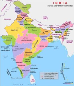
There are over 200 place names in India that begin with “TURK”. The list ranks numerous place names in India that start with “TURK,” along with information on state, latitude, altitude, and estimated population.
The real scientific question is:
How many of these 202 “TURK” place names are actually linked to the historical presence of Turkic/Turkic communities, and how many originate from an independent word, name, surname, or other etymology in Indian languages?
The geographical distribution is particularly interesting.
Looking at the list, the concentration is especially along the following axis:
Uttar Pradesh → Bihar → Andhra Pradesh/Telangana → Madhya Pradesh → Maharashtra → Karnataka
This provides a fairly good dataset for testing a simple claim of “accidental name similarity.”
Furthermore, it is necessary to examine the historical layers of these place names separately in terms of the arrival of Turks in India, the Ghaznavids, the Delhi Sultanate, the Mughals, and earlier Turkic movements.
In this study, we can particularly distinguish between places where the “Turk” element is truly a Turkic ethnonym, those derived from Turkic/Turkic personal names, those associated with Turkic military-administrative groups, and those with only phonetic similarities.
If this is done, the number 202 will cease to be a simple list and will transform into a serious toponymic study capable of testing the geographical traces of Turkic history in India.
“Atlas of Turkic Place Names in India”
Dividing the 202 place names into three historical geographical zones: North India / Central India / South India, and individually investigating the relationship of each with the Ghaznavid–Delhi Sultanate–Timurid/Mughal–Afghan-Turkic dynasties in Turkic history. This will make the study much stronger.
- 🇮🇳 Indian state/provincial borders
- 🔴🟠🟢 TURK / TURKA / TURKI settlements with a population of 50,000+
- Locations numbered 1–30
- Uttar Pradesh–Bihar zoom
- Table showing settlement name, state, and population
- Scale and compass
are included. You can clearly see the concentration, especially along the Uttar Pradesh–Bihar line.
Yes. If we take the 30 large TURK/TURKA/TURKI place-names on the map and then place them against the successive historical layers of Turkic presence in India, I think the most useful interpretation is not “30 places founded by Turks.” That would go beyond the evidence.
A stronger interpretation is that the 30 names may represent different deposits of a much older and continuously renewed Turkic military–administrative–settlement network. The network changes character over time.
The BooksOnTurkey list itself is a useful starting dataset: it records the names, regions, coordinates/elevations and population estimates, but it does not establish the date or reason why each individual village acquired the name “Turk.”
- The network I would propose
Think of India as receiving several Turkic waves, each using substantially the same northwestern geographical funnel:
Central Asia → Transoxiana → Afghanistan → Khyber/Ghazni → Punjab → Delhi → Ganga–Yamuna Doab → Awadh/Bihar → Bengal
with secondary branches:
Delhi → Rajasthan → Malwa → Deccan
and
Punjab/Delhi → Kashmir/Himalayan foothills
The remarkable thing about your 30-place map is that many of the large names sit inside or close to this later eastern extension of the network, particularly Uttar Pradesh and Bihar.
That is historically significant.
- Layer I — before Islam: the forgotten Turkic/Inner Asian frontier
We should start much earlier than Mahmud of Ghazni.
There were Central Asian peoples moving through the northwest of the subcontinent centuries before the Muslim conquest. The difficult point is terminology: “Turkic,” “Iranian,” “Scythian,” “Hunnic,” “Kushan” and “Central Asian” cannot simply be treated as interchangeable categories.
The Saka crossed into the northwest in antiquity; the Yuezhi subsequently transformed into the Kushan power; and the Hephthalites entered northern India in the fifth century. Encyclopaedia Iranica describes the Hephthalites as a major Central Asian power whose ruler Toramāṇa controlled much of northern and western India around 510 CE.
A Turkish connection has also been argued in older scholarship, including Aydın Sayılı’s analysis in Belleten, which identifies the Hephthalites as closely associated with, and in Islamic sources explicitly identified with, Turkish peoples.
But I would not use this layer as evidence that any of your 30 “Turk” villages are Hephthalite foundations.
Instead, it establishes something more important: The northwestern Indian subcontinent had been connected to Central Asian steppe populations for many centuries before the Ghaznavids.
So your map should have a deep-background layer, not a direct attribution layer.
- Layer II — the Ghaznavid network, c. 977–1186
This is where the historical connection becomes much firmer.
The Ghaznavids were a Turkish military dynasty, originating from the Samanid military system. Alptigin established himself at Ghazna; Sebüktigin consolidated the power; Mahmud then transformed it into an imperial military state.
And this is crucial for your map: Mahmud’s armies did not stop at Punjab.
They penetrated into the Ganges–Yamuna Doab and as far as Gwalior.
But we should distinguish:
Ghaznavid penetration ≠ permanent settlement everywhere they raided.
The Ghaznavid system was principally a military and fiscal system. Lahore subsequently became the capital of the reduced Ghaznavid state, making Punjab a much more permanent Turkish-Persian political zone.
So I would draw the first major network as:
Ghazna → Peshawar/Khyber → Lahore → Punjab → Doab → Gwalior
with Delhi and the Ganga plain as emerging destinations rather than fully established Turkic settlement zones.
- Layer III — Ghurids: the decisive bridge
This is perhaps the most important layer for understanding your 30 names.
The Ghurids captured Lahore in 1186, Delhi in 1192, Ajmer in 1193, Kannauj in 1198, and then Bakhtiyar Khalji moved eastward into Bihar and Bengal in 1202–04.
That creates almost exactly the geographical axis visible in your map:
Punjab → Delhi → Upper Ganga → Awadh → Bihar → Bengal
This was no longer simply a raiding corridor.
It became a state-building corridor.
And the Ghurid military commanders—many of them Turkish—became the foundations of the Delhi Sultanate.
So if I were constructing historical GIS, I would make the Ghurid layer thicker than the Ghaznavid layer in Uttar Pradesh and Bihar.
- Layer IV — Delhi Sultanate, 1206–1526
This is the layer where 30 place names become especially interesting.
The Delhi Sultanate was established by Central Asian Turkish military rulers and subsequently became increasingly Persianized.
But the critical mechanism was not simply “Turks conquered India.”
It was:
military service → iqta/land assignment → garrison → administrative centre → agricultural revenue → local settlement → family formation → village identity
The early Delhi Sultanate developed an extensive military-administrative apparatus inherited from the Ghaznavid and Ghurid worlds.
And there was substantial migration into northern India.
After the Mongol invasions of Central Asia and Khurasan in the 13th century, large numbers of Persianized Turks moved into northern India and supplied administrative and military manpower to the Delhi Sultanate.
This is where a name such as:
Turk + local geographical name
could become historically plausible.
Not necessarily:
“A Turkish army camped here.”
But potentially:
“A community, landholding group, military household, or population locally identified as Turk became sufficiently established here for the locality to acquire the designation.”
That is a much more interesting hypothesis.
- Why Uttar Pradesh is so important
Look at map again.
The biggest concentration is not Punjab.
It is Uttar Pradesh and Bihar.
That tells us something about the difference between the original entry zone and the eventual demographic zone.
Punjab was the gateway.
Delhi was the political engine.
The Ganga plain became the demographic and agrarian expansion zone.
This fits the historical evidence very well. The upper Jumna–Ganges plain contained important Sultanate garrison and administrative centres such as Baran, Etawah, Badaun and Kannauj, which became increasingly Persianized.
Your TURK toponyms therefore deserve to be studied as possible remnants of the rural hinterland of the Indo-Turkic political system, rather than only as traces of invasion routes.
- Bihar is an especially interesting second node
Map shows several large TURK names in Bihar.
That is not geographically random.
Bihar became connected to the Turkish military expansion under Bakhtiyar Khalji around 1202–04.
So we have:
Delhi/Doab → eastern Ganga corridor → Bihar → Bengal
The eastern frontier was not merely cultural.
It was a military frontier, revenue frontier and migration frontier.
That makes Bihar one of the places where I would most seriously investigate whether particular TURK toponyms correspond to:
- military settlements
- Turkic/Islamicate landholders
- descendants of military households
- jagir/iqta territories
- Afghan-Turkic mixed populations
- later Mughal mansabdars
- or simply local naming traditions.
- Layer V — Khalji and Tughluq expansion
The next network enlargement occurs under the Khaljis and Tughluqs.
The Khaljis were themselves Turkish or Turkicized, while the Tughluqs emerged from the Punjab frontier and expanded the Sultanate enormously.
This is important because the network becomes pan-Indian.
The Sultanate’s administrative and military practices spread as far as Malwa, the Deccan and Bengal.
Therefore the isolated TURK names you have in:
- Karnataka
- Maharashtra
- Andhra/Telangana
- Rajasthan
- Chhattisgarh
should not automatically be treated as unrelated anomalies.
They may represent secondary branches of the same wider military-administrative system.
But they need individual historical investigation.
- Layer VI — the Mughal transformation
Then comes a major change:
1526 — Babur.
The Mughal network is not simply another Turkish penetration.
It is a Timurid–Turani–Persianate imperial network.
Under Akbar, the system became much more sophisticated. The mansabdari system organized officials and military commanders into a centrally controlled hierarchy; officials were frequently transferred, while jagirs became an important mechanism of remuneration.
This creates another mechanism for your TURK names:
Turani noble → mansab → jagir → military retinue → landholding → settlement → local memory/toponym
That is potentially a very powerful explanation for some later names.
But again, we need documentary proof for each locality.
- The really interesting conclusion: these are not five separate networks
I would actually draw your historical model as one network with five successive operating systems:
NETWORK 1
Ancient Central Asian movements
↓
NETWORK 2
Ghaznavid military corridor
Ghazna → Lahore → Punjab → Doab
↓
NETWORK 3
Ghurid conquest corridor
Punjab → Delhi → Kannauj → Bihar → Bengal
↓
NETWORK 4
Delhi Sultanate settlement/administrative network
Delhi → Ganga–Yamuna → Awadh → Bihar
plus branches to:
Rajasthan / Malwa / Deccan / Bengal
↓
NETWORK 5
Mughal Turani mansab–jagir network
Agra/Delhi/Lahore → provincial capitals → jagirs → local settlements
The important point is that each layer inherited infrastructure from the previous one.
- And that gives us a very interesting hypothesis for the 30 names
I would divide the 30 TURK places into four hypothetical historical classes:
| Class | Possible origin | Expected period |
| A. Frontier Turk | military/tribal groups entering from northwest | pre-1200 |
| B. Sultanate Turk | Turkish military settlers, iqta/garrison communities | 1200–1526 |
| C. Mughal Turk/Turani | mansabdar/jagir/retinue settlement | 1526–1700s |
| D. Memory name | later community retained “Turk” as ethnic/social designation | 1700s–modern |
The same word Turk could therefore represent completely different historical moments.
That is why I would not date the names merely from their spelling.
- There is an even deeper pattern
30-place map potentially reveals a three-stage geography of Turkic presence:
① GATEWAY
Punjab / northwest
Turkic military power enters India.
② IMPERIAL CORE
Delhi–Agra–Ganga-Yamuna
Turkic military elites become an Indian ruling class.
③ AGRARIAN DIFFUSION
Uttar Pradesh–Bihar–Bengal
Military and administrative elites become embedded in the countryside.
That third stage is, in my view, the most important discovery your map could potentially illuminate.
The historical sources clearly document the movement of Turkic and Persianized military-administrative populations into northern India.
What is not yet demonstrated is whether your individual TURK village names preserve that history.
That is the research question.
- I would therefore build a “TURK India Historical Network Map”
Not just the present-day map.
I would make six chronological GIS layers:
|
Layer 1 — Pre-Islamic Central Asian movements Layer 2 — 977–1186 Layer 3 — 1175–1206 Layer 4 — 1206–1526 Layer 5 — 1526–1707 Layer 6 — 1707–1900
|
Then place the 30 TURK settlements on top of all six layers.
That would allow us to ask, for every individual place:
Which historical corridor could have produced this name?
rather than assuming that every “Turk” means the same thing.
My preliminary conclusion
The strongest historical connection is not “Ghaznavids founded these 30 towns.”
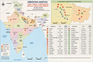
A distribution map of the 30 most populous place names among over 200 place names with Turkish prefixes in India. The highest concentration is in the two northern and northeastern states.
Hindistan’da Türk ön takılı 200’ü aşkın yer adı içinde en yüksek nüfuslu 30 yer adının dağılım haritası. Yoğunluk kuzey ve kuzey doğudaki 2 eyalette.
● 🇮🇳 Indian state/provincial borders
● 🔴🟠🟢 TURK suffix settlements with a population of 50,000+
● Locations number 1–30
● Uttar Pradesh–Bihar zoom
● Settlement name, state and population table
● Scale and compass
You can clearly see the concentration especially on the Uttar Pradesh-Bihar line.
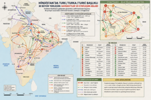
Movements and Interactions of the Cities on the Map
It is:
The 30 TURK toponyms appear potentially compatible with the long-term eastward diffusion of a Central Asian military–administrative world: Ghaznavid Punjab → Ghurid conquest → Delhi Sultanate → Ganga–Yamuna/Awadh → Bihar/Bengal → Mug est medieval city/fort → Sultanate-era district → Mughal sarkar/pargana → historical rulers → inscriptions/revenue records → earliest known occurrence of the name → linguistic analysis of “Turk” + suffix. That would let us separate documented Turkic settlement from merely suggestive toponymy.
| ŞEHİR | BÖLGE | ENLEM | BOYLAM | RAKIM | NÜFUS |
| http://fallingrain.com/world/IN/a/T/u/r/k/ | |||||
| TURK | |||||
| Name | Region | Lat | Long | Elev ft. | Pop est |
| Turk Ainjani | Bihar | 25.22 | 85.99 | 124 | 68.384 |
| Turk Bigha | Bihar | 25.11. | 84.41 | 269 | 106.557 |
| Turk Garhwa | Uttar Pradesh | 25.96 | 83.68 | 200 | 56.833 |
| Turk Lalai | Uttar Pradesh | 27.51 | 79.38 | 830 | 73.661 |
| Turk Madhwaram | Karnataka | 16.65 | 77.34 | 1669 | 21.605 |
| Turk Mādhawār | Karnataka | 16.65 | 77.34 | 1669 | 21.605 |
| Turk Wadgaon | Andhra Pradesh | 18.19 | 77.62 | 1738 | 20.060 |
| Turk Wāngom | Jammu and Kashmir | 33.78 | 74.94 | 5869 | 71.578 |
| TURKA | |||||
| Name | Region | Lat | Long | Elev ft. | Pop est |
| Turka | Madhya Pradesh | 24.78 | 79.24 | 921 | 25.466 |
| Turka | Maharashtra | 20.97 | 79.63 | 830 | 26.936 |
| Turka | Uttar Pradesh | 24.86 | 78.63 | 1023 | 21.564 |
| Turka | Uttar Pradesh | 27.19 | 81.80 | 383 | 52.003 |
| Turka | Uttar Pradesh | 25.23 | 81.16 | 830 | 27.556 |
| Turka | Madhya Pradesh | 25.03. | 81.47 | 400 | 37.765 |
| Turka | Madhya Pradesh | 23.19 | 80.32 | 1669 | 15.049 |
| Turka | Odisha | 19.81 | 83.24 | 2509 | 16.539 |
| Turka Dih | Uttar Pradesh | 27.10. | 82.15 | 321 | 62.881 |
| Turka Lahchura | Uttar Pradesh | 25.52 | 79.23 | 830 | 17.135 |
| Turka Lahchūra | Uttar Pradesh | 25.51 | 79.22 | 830 | 17.135 |
| Turka Tachul | Jammu and Kashmir | 33.74 | 75.09 | 5239 | 51.914 |
| Turkabar | Bihar | 24.59 | 84.43 | 830 | 43.085 |
| Turkadih | Chhattisgarh | 21.82 | 83.10 | 830 | 45.600 |
| Turkadih | Jharkhand | 24.37 | 84.30 | 885 | 32.166 |
| Turkadiha | Uttar Pradesh | 27.02. | 82.15 | 324 | 73.232 |
| Turkadiha | Uttar Pradesh | 26.92 | 82.48 | 265 | 67.941 |
| Turkadinni | Andhra Pradesh | 16.29 | 78.23 | 1669 | 22.496 |
| Turkadīha | Uttar Pradesh | 27.03. | 82.54 | 288 | 69.359 |
| Turkagori | Uttarakhand | 28.97 | 79.51 | 830 | 68.905 |
| Turkaguda | Andhra Pradesh | 17.32 | 78.81 | 1669 | 29.651 |
| Turkaguda | Andhra Pradesh | 17.15 | 78.62 | 1833 | 28.569 |
| Turkaguda | Andhra Pradesh | 17.10. | 78.53 | 1922 | 22.845 |
| Turkaguda | Andhra Pradesh | 17.31 | 78.80 | 1669 | 29.757 |
| Turkagudem | Andhra Pradesh | 17.21 | 79.78 | 830 | 30.695 |
| Turkagudem | Andhra Pradesh | 17.65 | 78.30 | 1748 | 30.042 |
| Turkagūdem | Andhra Pradesh | 17.24 | 79.97 | 830 | 24.915 |
| Turkaha | Bihar | 25.17 | 83.97 | 242 | 69.628 |
| Turkaha | Madhya Pradesh | 24.53 | 80.69 | 1105 | 22.482 |
| Turkaha | Uttar Pradesh | 25.06. | 82.54 | 830 | 63.239 |
| Turkaha | Uttar Pradesh | 26.87 | 83.67 | 255 | 46.625 |
| Turkaha | Uttar Pradesh | 25.17 | 81.99 | 295 | 30.698 |
| Turkaha | Bihar | 26.49 | 86.19 | 187 | 98.116 |
| Turkahi | Uttar Pradesh | 25.53 | 83.26 | 131 | 103.981 |
| Turkahi | Bihar | 25.88 | 86.83 | 134 | 153.364 |
| Turkahia | Uttar Pradesh | 26.79 | 82.73 | 259 | 165.656 |
| Turkai Khanapur | Andhra Pradesh | 17.68 | 78.21 | 1696 | 30.083 |
| Turkaili | Bihar | 26.11. | 87.53 | 187 | 146.532 |
| Turkakol | Bihar | 24.78 | 87.01 | 314 | 55.526 |
| Turkal Khanapur | Andhra Pradesh | 17.68 | 78.21 | 1696 | 30.083 |
| Turkal Maddikunta | Andhra Pradesh | 18.64 | 79.33 | 941 | 41.522 |
| Turkal Muhammadapur | Andhra Pradesh | 18.02. | 78.35 | 1669 | 34.967 |
| Turkalagudem | Andhra Pradesh | 17.58 | 81.24 | 62 | 12.694 |
| Turkalapalli | Andhra Pradesh | 16.60 | 78.45 | 1669 | 28.308 |
| Turkalmettu | Andhra Pradesh | 18.12. | 82.81 | 3349 | 17.692 |
| Turkalua | Uttar Pradesh | 27.06. | 82.49 | 288 | 65.141 |
| Turkamalla | Andhra Pradesh | 17.29 | 79.29 | 830 | 28.708 |
| Turkan Purwa | Uttar Pradesh | 26.87 | 79.81 | 830 | 64.583 |
| Turkandoni | Karnataka | 16.01. | 77.33 | 1141 | 24.554 |
| Turkani | Uttar Pradesh | 26.91 | 81.38 | 357 | 55.625 |
| Turkania | Uttar Pradesh | 26.49 | 82.91 | 255 | 72.363 |
| Turkanian | Uttar Pradesh | 28.36 | 79.54 | 830 | 46.407 |
| Turkanpur | Haryana | 28.28 | 76.81 | 830 | 84.225 |
| Turkanwali | Haryana | 29.34 | 75.15 | 830 | 28.680 |
| Turkapalem | Andhra Pradesh | 16.32 | 80.63 | 52 | 92.556 |
| Turkapalem | Andhra Pradesh | 16.32 | 80.97 | 19 | 63.567 |
| Turkapalle | Andhra Pradesh | 16.62 | 80.11 | 131 | 27.593 |
| Turkapalli | Andhra Pradesh | 17.67 | 78.59 | 1919 | 42.485 |
| Turkapalli | Andhra Pradesh | 17.65 | 78.83 | 1755 | 18.781 |
| Turkapalli | Andhra Pradesh | 18.27 | 77.93 | 1669 | 35.154 |
| Turkapalli | Andhra Pradesh | 18.08. | 77.77 | 1669 | 34.896 |
| Turkapalli | Andhra Pradesh | 16.91 | 78.37 | 1893 | 22.290 |
| Turkapalli | Andhra Pradesh | 17.43 | 79.11 | 1243 | 23.155 |
| Turkapalli | Andhra Pradesh | 17.35 | 79.23 | 830 | 27.111 |
| Turkapalli | Andhra Pradesh | 17.43 | 79.12 | 1171 | 23.075 |
| Turkapalli | Andhra Pradesh | 18.05. | 79.32 | 1679 | 35.437 |
| Turkapalli | Andhra Pradesh | 17.54 | 78.52 | 1958 | 216.148 |
| Turkapur | Jammu and Kashmir | 34.42 | 74.22 | 5357 | 27.405 |
| Turkapālem | Andhra Pradesh | 16.56 | 80.22 | 124 | 43.545 |
| Turkapālem | Andhra Pradesh | 16.00 | 80.60 | 32 | 65.082 |
| Turkapālem | Andhra Pradesh | 16.59 | 79.87 | 242 | 26.564 |
| Turkariya | Rajasthan | 24.41 | 76.59 | 997 | 27.153 |
| Turkatri | Madhya Pradesh | 24.94 | 80.16 | 830 | 23.438 |
| Turkaul | Bihar | 25.41 | 84.74 | 170 | 149.242 |
| Turkaul | Bihar | 25.18 | 84.92 | 200 | 116.210 |
| Turkauli | Uttar Pradesh | 25.82 | 82.30 | 249 | 72.037 |
| Turkauli | Uttar Pradesh | 25.96 | 82.41 | 265 | 172.696 |
| Turkauli | Uttar Pradesh | 27.18 | 82.46 | 318 | 130.786 |
| Turkauli | Uttar Pradesh | 27.02. | 82.36 | 318 | 65.157 |
| Turkauli | Uttar Pradesh | 26.06. | 82.38 | 252 | 77.069 |
| Turkauli | Uttar Pradesh | 26.00 | 82.58 | 288 | 99.569 |
| Turkauli | Uttar Pradesh | 26.65 | 83.16 | 229 | 55.970 |
| Turkauli | Uttar Pradesh | 26.28 | 83.30 | 213 | 90.826 |
| Turkauli | Uttar Pradesh | 27.28 | 81.30 | 390 | 63.884 |
| Turkauli Khas | Uttar Pradesh | 27.03. | 82.60 | 288 | 86.193 |
| Turkaulia | Bihar | 26.72 | 84.24 | 223 | 163.432 |
| Turkaulia | Bihar | 25.24 | 83.65 | 213 | 72.105 |
| Turkaulia | Uttar Pradesh | 27.17 | 82.00 | 341 | 95.507 |
| Turkaulia | Uttar Pradesh | 27.56 | 82.17 | 351 | 29.055 |
| Turkaulia | Uttar Pradesh | 27.13 | 82.65 | 288 | 139.127 |
| Turkaulia | Uttar Pradesh | 27.07. | 82.87 | 282 | 87.376 |
| Turkaulia | Uttar Pradesh | 26.96 | 82.65 | 252 | 89.652 |
| Turkaulia | Uttar Pradesh | 26.74 | 82.99 | 249 | 89.535 |
| Turkaulia | Uttar Pradesh | 27.21 | 83.06 | 291 | 94.079 |
| Turkaulia | Uttar Pradesh | 27.23 | 83.40 | 288 | 68.198 |
| Turkaulia | Uttar Pradesh | 26.51 | 83.02 | 232 | 105.041 |
| Turkaulia | Uttar Pradesh | 26.52 | 83.13 | 229 | 340.344 |
| Turkaulia | Uttar Pradesh | 26.64 | 83.24 | 226 | 61.602 |
| Turkaulia | Uttar Pradesh | 26.45 | 83.21 | 216 | 120.979 |
| Turkaulia | Uttar Pradesh | 26.88 | 83.25 | 203 | 44.886 |
| Turkaulia | Uttar Pradesh | 26.31 | 83.65 | 216 | 75.362 |
| Turkaulia | Uttar Pradesh | 26.79 | 83.85 | 236 | 60.138 |
| Turkaulia | Uttar Pradesh | 26.79 | 83.90 | 236 | 70.830 |
| Turkaulia | Bihar | 25.85 | 84.71 | 170 | 166.041 |
| Turkaulia Bargāh | Uttar Pradesh | 26.76 | 82.87 | 259 | 89.989 |
| Turkaulia Nāik | Uttar Pradesh | 26.49 | 83.02 | 226 | 112.984 |
| Turkaulia Rai | Uttar Pradesh | 27.10. | 82.74 | 288 | 99.562 |
| Turkaulia Tiwāri | Uttar Pradesh | 27.17 | 82.75 | 285 | 137.982 |
| Turkaulia Urf Nāthpur | Uttar Pradesh | 26.33 | 83.37 | 232 | 93.666 |
| Turkauliya | Bihar | 26.61 | 84.83 | 213 | 140.898 |
| Turkauliya | Bihar | 25.07. | 84.25 | 262 | 113.372 |
| Turkaulla | Bihar | 26.61 | 84.83 | 213 | 140.898 |
| Turkaura | Uttarakhand | 29.66 | 79.53 | 5892 | 27.934 |
| Turkavanipalli | Andhra Pradesh | 16.46 | 78.05 | 1669 | 27.812 |
| TURKD | |||||
| Name | Region | Lat | Long | Elev ft. | Pop est |
| Turkdiha | Uttar Pradesh | 26.82 | 83.65 | 255 | 44.902 |
| TURKE | |||||
| Name | Region | Lat | Long | Elev ft. | Pop est |
| Turkehla | Uttar Pradesh | 27.47 | 79.70 | 830 | 52.081 |
| Turkevadi | Maharashtra | 15.88 | 74.33 | 2509 | 28.740 |
| TURKH | |||||
| Name | Region | Lat | Long | Elev ft. | Pop est |
| Turkhandiāl Khol | Uttarakhand | 29.95 | 78.77 | 4189 | 20.403 |
| Turkharsa | Bihar | 25.15 | 84.53 | 242 | 48.722 |
| Turkhaulia | Uttar Pradesh | 27.39 | 82.28 | 344 | 29.830 |
| Turkhed | Maharashtra | 21.18 | 77.17 | 1253 | 26.934 |
| Turkhed | Maharashtra | 20.67 | 77.41 | 1010 | 28.522 |
| Turkheda | Maharashtra | 21.13 | 75.55 | 830 | 47.913 |
| Turkhera | Uttar Pradesh | 28.60 | 78.87 | 830 | 89.259 |
| Turkheri Kalān | Punjab | 30.54 | 76.31 | 839 | 36.475 |
| Turkheri Khurd | Punjab | 30.54 | 76.32 | 839 | 33.958 |
| Turkheta Hathatpur | Uttar Pradesh | 27.96 | 80.23 | 830 | 45.065 |
| Turkheta Patti Gokan | Uttar Pradesh | 27.97 | 80.16 | 830 | 43.462 |
| TURKİ | |||||
| Name | Region | Lat | Long | Elev ft. | Pop est |
| Turki | Bihar | 26.04. | 85.36 | 160 | 181.197 |
| Turki | Bihar | 25.16 | 83.80 | 229 | 83.044 |
| Turki | Madhya Pradesh | 24.56 | 81.12 | 1003 | 37.981 |
| Turki | Madhya Pradesh | 24.54 | 81.12 | 1010 | 36.921 |
| Turki | Madhya Pradesh | 24.55 | 81.14 | 1007 | 50.128 |
| Turki | Madhya Pradesh | 24.59 | 81.34 | 1026 | 72.543 |
| Turki | Madhya Pradesh | 24.23 | 81.09 | 1145 | 33.262 |
| Turki | Bihar | 24.88 | 83.81 | 318 | 43.010 |
| Turki | Bihar | 24.98 | 83.99 | 269 | 99.400 |
| Turki | Uttar Pradesh | 27.08. | 80.89 | 403 | 41.247 |
| Turki | Bihar | 25.64 | 84.69 | 170 | 91.037 |
| Turki | Bihar | 26.13 | 84.86 | 200 | 111.551 |
| Turki | Bihar | 25.21 | 84.03 | 246 | 74.903 |
| Turki | Bihar | 26.03. | 86.07 | 144 | 122.183 |
| Turki | Bihar | 25.74 | 86.66 | 121 | 86.244 |
| Turki | Bihar | 25.57 | 87.26 | 95 | 85.329 |
| Turki | Bihar | 25.85 | 85.12 | 134 | 80.674 |
| Turki | Bihar | 25.83 | 85.32 | 144 | 221.726 |
| Turki Baghela | Uttar Pradesh | 25.88 | 82.60 | 275 | 104.061 |
| Turki Bari | Uttar Pradesh | 25.89 | 84.03 | 193 | 88.560 |
| Turki Daulatpur | Uttar Pradesh | 26.03. | 83.91 | 203 | 95.062 |
| Turki Khera | Uttar Pradesh | 27.76 | 80.04 | 830 | 33.366 |
| Turkia | Uttar Pradesh | 27.18 | 77.69 | 830 | 64.553 |
| Turkia | Uttar Pradesh | 28.16 | 79.95 | 830 | 47.925 |
| Turkia | Bihar | 25.53 | 86.25 | 118 | 156.549 |
| Turkiapur | Uttar Pradesh | 26.76 | 79.91 | 830 | 30.723 |
| Turkimau | Uttar Pradesh | 26.26 | 80.00 | 416 | 37.257 |
| Turkindih | Chhattisgarh | 21.64 | 82.54 | 830 | 12.254 |
| Turkinia | Uttar Pradesh | 25.93 | 81.68 | 305 | 158.801 |
| Turkipur | Uttar Pradesh | 26.71 | 82.46 | 272 | 82.985 |
| Turkipur Ki Marhaiyan | Uttar Pradesh | 26.55 | 79.50 | 830 | 76.267 |
| Turkipur Phaphūnd | Uttar Pradesh | 26.55 | 79.49 | 830 | 74.917 |
| Turkipura | Uttar Pradesh | 27.43 | 78.84 | 830 | 62.141 |
| Turkipura | Uttar Pradesh | 28.20 | 78.07 | 830 | 88.936 |
| Turkiāpur | Uttar Pradesh | 26.75 | 79.91 | 830 | 31.153 |
| Turkiāpurwa | Uttar Pradesh | 27.86 | 81.42 | 410 | 4.886 |
| TURKO | |||||
| Name | Region | Lat | Long | Elev ft. | Pop est |
| Turkoha | Madhya Pradesh | 24.80 | 80.99 | 980 | 24.471 |
| Turkonibavi | Andhra Pradesh | 16.93 | 79.18 | 830 | 21.190 |
| Turkonkunta Tānda | Andhra Pradesh | 17.47 | 78.22 | 1801 | 93.313 |
| TURKP | |||||
| Name | Region | Lat | Long | Elev ft. | Pop est |
| Turkpatti | Uttar Pradesh | 26.76 | 84.06 | 232 | 91.395 |
| Turkpur | Jammu and Kashmir | 34.44 | 74.59 | 5869 | 29.266 |
| Turkpur | Haryana | 28.89 | 76.98 | 830 | 50.811 |
| Turkpur | Uttar Pradesh | 26.25 | 82.71 | 282 | 80.426 |
| Turkpur | Uttar Pradesh | 28.65 | 79.87 | 830 | 95.820 |
| Turkpur | Uttar Pradesh | 26.72 | 79.38 | 830 | 60.643 |
| Turkpur Bhagwān Dās | Uttar Pradesh | 26.51 | 79.39 | 830 | 44.861 |
| Turkpura | Uttar Pradesh | 26.91 | 77.56 | 830 | 49.932 |
| TURKU | |||||
| Name | Region | Lat | Long | Elev ft. | Pop est |
| Turkuniān | Uttar Pradesh | 28.78 | 79.77 | 830 | 45.282 |
| TURKY | |||||
| Name | Region | Lat | Long | Elev ft. | Pop est |
| Turkya | Rajasthan | 26.51 | 76.08 | 967 | 23.830 |
| TURKā | |||||
| Name | Region | Lat | Long | Elev ft. | Pop est |
| Turkābād Khardi | Maharashtra | 19.79 | 75.17 | 1669 | 46.359 |
| Turkādīh | Chhattisgarh | 22.14 | 82.11 | 898 | 118.678 |
| Turkādīh | Jharkhand | 24.06. | 84.17 | 830 | 56.740 |
| Turkādīha | Uttar Pradesh | 27.17 | 82.00 | 341 | 91.480 |
| Turkāha | Uttar Pradesh | 26.39 | 80.80 | 400 | 59.379 |
| Turkāhipur | Uttar Pradesh | 26.30 | 83.11 | 239 | 246.534 |
| Turkāi | Madhya Pradesh | 23.79 | 79.29 | 1145 | 23.562 |
| Turkāni Bāgh | Uttar Pradesh | 26.41 | 82.71 | 269 | 82.511 |
| Turkānpura | Uttar Pradesh | 25.92 | 82.21 | 282 | 87.507 |
| Turkāpalli | Andhra Pradesh | 16.35 | 78.79 | 1991 | 3.574 |
| Turkāpur | Uttar Pradesh | 25.19 | 82.62 | 272 | 116.937 |
| TURKİ | |||||
| Name | Region | Lat | Long | Elev ft. | Pop est |
| Turkīgosāin | Madhya Pradesh | 24.40 | 81.16 | 990 | 27.856 |
| Turkīkhāpa | Madhya Pradesh | 21.88 | 78.92 | 2037 | 40.278 |
| Turkīpur | Uttar Pradesh | 27.42 | 79.50 | 830 | 65.499 |
| Turkīpur Chittarsingh | Uttar Pradesh | 26.49 | 79.53 | 830 | 144.453 |
| Turkīpāra | Rajasthan | 24.62 | 76.91 | 1085 | 21.170 |
| Turkītāl | Madhya Pradesh | 24.45 | 80.42 | 1184 | 28.718 |
To the City: Life and Death Along the Ancient Walls of Istanbul
$3.90 (as of 12/10/2026 03:03 GMT +03:00 - More infoProduct prices and availability are accurate as of the date/time indicated and are subject to change. Any price and availability information displayed on [relevant Amazon Site(s), as applicable] at the time of purchase will apply to the purchase of this product.)
Rough Guides Turkiye: Travel Guide with eBook: 2026-2027 | Insider Tips | Must-See Sights | Maps & Itineraries | Covers: Istanbul, Cappadocia, the Turquoise Coast and more
$21.39 (as of 12/10/2026 03:03 GMT +03:00 - More infoProduct prices and availability are accurate as of the date/time indicated and are subject to change. Any price and availability information displayed on [relevant Amazon Site(s), as applicable] at the time of purchase will apply to the purchase of this product.)
Istanbul Travel Guide 2025: Discover Istanbul’s Top Attractions, Hidden Gems, Cultural Highlights, Timely Itineraries, and Budget-Friendly Hacks for Every Traveler
$0.99 (as of 12/10/2026 03:03 GMT +03:00 - More infoProduct prices and availability are accurate as of the date/time indicated and are subject to change. Any price and availability information displayed on [relevant Amazon Site(s), as applicable] at the time of purchase will apply to the purchase of this product.)
The Essential Travel Guide To Turkiye: Iconic Sights, Authentic Food and Smart Travel Tips From A Local (Istanbul, Cappadocia, Antalya and Beyond)
$2.99 (as of 12/10/2026 03:03 GMT +03:00 - More infoProduct prices and availability are accurate as of the date/time indicated and are subject to change. Any price and availability information displayed on [relevant Amazon Site(s), as applicable] at the time of purchase will apply to the purchase of this product.)
Laminated Istanbul Map by Borch (English) (English, Spanish, French, Italian and German Edition)
$9.95 (as of 12/10/2026 03:03 GMT +03:00 - More infoProduct prices and availability are accurate as of the date/time indicated and are subject to change. Any price and availability information displayed on [relevant Amazon Site(s), as applicable] at the time of purchase will apply to the purchase of this product.)
Notes on a Foreign Country: An American Abroad in a Post-American World
$9.39 (as of 12/10/2026 03:03 GMT +03:00 - More infoProduct prices and availability are accurate as of the date/time indicated and are subject to change. Any price and availability information displayed on [relevant Amazon Site(s), as applicable] at the time of purchase will apply to the purchase of this product.)
The Turkish Cookbook
$42.95 (as of 12/10/2026 03:03 GMT +03:00 - More infoProduct prices and availability are accurate as of the date/time indicated and are subject to change. Any price and availability information displayed on [relevant Amazon Site(s), as applicable] at the time of purchase will apply to the purchase of this product.)
Blue Mosque: Where Heaven Meets the Sky – A Cinematic Photographic Journey Through Istanbul's Sultan Ahmed Masterpiece
$10.99 (as of 12/10/2026 03:03 GMT +03:00 - More infoProduct prices and availability are accurate as of the date/time indicated and are subject to change. Any price and availability information displayed on [relevant Amazon Site(s), as applicable] at the time of purchase will apply to the purchase of this product.)
DK Top 10 Istanbul: Top 10 lists for your perfect trip, plus an all-weather folded map (Pocket Travel Guide)
$6.46 (as of 12/10/2026 03:03 GMT +03:00 - More infoProduct prices and availability are accurate as of the date/time indicated and are subject to change. Any price and availability information displayed on [relevant Amazon Site(s), as applicable] at the time of purchase will apply to the purchase of this product.)
Easy Turkish Phrase Book for Travel: 1500+ Essential Phrases for Vacation, Restaurants, Hotels & Everyday Conversations in Turkey: The Ultimate Guide ... Local Slang & Essential Survival Phrases
$10.99 (as of 12/10/2026 03:03 GMT +03:00 - More infoProduct prices and availability are accurate as of the date/time indicated and are subject to change. Any price and availability information displayed on [relevant Amazon Site(s), as applicable] at the time of purchase will apply to the purchase of this product.)
Istanbul For First Timers: A Local's Travel Guide To Turkiye's Hidden Gems and Culture
$4.99 (as of 12/10/2026 02:51 GMT +03:00 - More infoProduct prices and availability are accurate as of the date/time indicated and are subject to change. Any price and availability information displayed on [relevant Amazon Site(s), as applicable] at the time of purchase will apply to the purchase of this product.)
Out of Istanbul: A Journey of Discovery Along the Silk Road
$17.89 (as of 12/10/2026 02:51 GMT +03:00 - More infoProduct prices and availability are accurate as of the date/time indicated and are subject to change. Any price and availability information displayed on [relevant Amazon Site(s), as applicable] at the time of purchase will apply to the purchase of this product.)
Shadow of the Silk Road
$17.03 (as of 12/10/2026 02:51 GMT +03:00 - More infoProduct prices and availability are accurate as of the date/time indicated and are subject to change. Any price and availability information displayed on [relevant Amazon Site(s), as applicable] at the time of purchase will apply to the purchase of this product.)
Rick Steves Istanbul: With Ephesus & Cappadocia
$10.46 (as of 12/10/2026 02:51 GMT +03:00 - More infoProduct prices and availability are accurate as of the date/time indicated and are subject to change. Any price and availability information displayed on [relevant Amazon Site(s), as applicable] at the time of purchase will apply to the purchase of this product.)
Istanbul: Memories and the City (Vintage International)
$11.94 (as of 12/10/2026 02:51 GMT +03:00 - More infoProduct prices and availability are accurate as of the date/time indicated and are subject to change. Any price and availability information displayed on [relevant Amazon Site(s), as applicable] at the time of purchase will apply to the purchase of this product.)
Istanbul: City of Majesty at the Crossroads of the World
$7.99 (as of 12/10/2026 02:51 GMT +03:00 - More infoProduct prices and availability are accurate as of the date/time indicated and are subject to change. Any price and availability information displayed on [relevant Amazon Site(s), as applicable] at the time of purchase will apply to the purchase of this product.)
Great Tours: Greece and Turkey, from Athens to Istanbul
$18.73 (as of 12/10/2026 02:51 GMT +03:00 - More infoProduct prices and availability are accurate as of the date/time indicated and are subject to change. Any price and availability information displayed on [relevant Amazon Site(s), as applicable] at the time of purchase will apply to the purchase of this product.)
Istanbul Travel Guide 2025: Discover Istanbul’s Top Attractions, Hidden Gems, Cultural Highlights, Timely Itineraries, and Budget-Friendly Hacks for Every Traveler
$0.99 (as of 12/10/2026 02:51 GMT +03:00 - More infoProduct prices and availability are accurate as of the date/time indicated and are subject to change. Any price and availability information displayed on [relevant Amazon Site(s), as applicable] at the time of purchase will apply to the purchase of this product.)
A Vintage Year: Traveling Free at the End of the Age of Innocence
$16.00 (as of 12/10/2026 02:51 GMT +03:00 - More infoProduct prices and availability are accurate as of the date/time indicated and are subject to change. Any price and availability information displayed on [relevant Amazon Site(s), as applicable] at the time of purchase will apply to the purchase of this product.)